Historic Overton
A 1.8 mile (2.8 km) walk highlighting historic features of Overton
This is an extract from the leaflet. The printable leaflet is available to download from our online library.
The original village of Overton is believed to have been to the north of the River Test. Overton was re-established to the south of the river in about 1200 as a "new town".
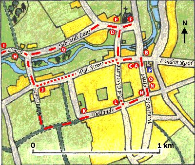
The Community Centre (A) was built in 1868 and used to be the village school. Before the school, The Poyntz Arms was on this site, which was a staging inn for coaches between London and Plymouth. The coach traffic declined when the railway opened in 1854. The White Hart (B) was another coaching inn, parts of which date from the 17th century.
Turn left into the High Street. Many of the old buildings in the High Street have even older buildings behind their façades, "Hobbs (C)" at no 7 is a 16th century timber-framed building. Several other 16th century timber-framed buildings can be spotted if you look at their side walls. Cross the High Street opposite Overton Gallery.
Turn right into Bridge Street. This was the original main route from the north. The thatched cottages date from the 18th Century and have an earlier timber-frame core.
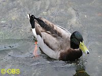
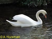
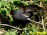
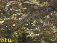
There is usually a "gang" of hungry mallards at the bridge. Other water birds include swan, coot and moorhen. Brown trout can be seen from the bridge. Look out for them well camouflaged against the gravel river bed.
At the end of Bridge Street on the left is the gothic mid 19th century Old Rectory (D). Opposite is Court Farm (E) which is another 16th century building with a more recent 18th century façade. In the farmyard is a medieval timber barn. The bailiff of the Bishops of Winchester held the manorial courts here.
Turn right into Church Road to St Mary's Church (F). Much of the outside of the church is 19th and early 20th century, but the south doorway is Norman. The nave arcade has round piers with pointed arches of the late 12th century.
Retrace your steps along Church Road and go straight on into Court Drove. This was one of a number of droveways along which flocks and herds of animals were moved around the country before rail and road transport became available.
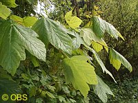
At the post box turn left into Silk Mill Lane which takes its name from the Silk Mill (G) that stood on the river. The mill was demolished in the 1840s. Children from the workhouse were employed as cheap labour. Walk alongside the wall, stop at the gate beyond the end and listen for the sound of water passing over the sluices. Imagine this tranquil environment as a busy factory with machinery clanking in the tall mill. The area is now reverting to scrub and woodland, predominately sycamore.
Continue along Silk Mill Lane and pass the cottages and then straight on into the Lynch.
On the left is Southington Mill (H), an 18th century corn mill and on the right the thatched Shadwells (I), formerly a pair of 18th century cottages.
As the road bends sharply right and uphill stop to take in the view across the mill stream and river. Perhaps sit a while on Ted Ralf's seat.
Retrace your steps along the Lynch and turn right to the first bridge in Southington Lane. Upstream note the 'green corridor' of long vegetation so critical for wildlife. Downstream glimpse Southington Mill again through the weeping willows.
Continue along Southington Lane. Just upstream from the next bridge is a lake where waterfowl can be seen. This area and the one downstream was once a watercress bed, which, like the mills, made use of the clear, fast running waters of the River Test.
At the cross roads you can see Tithe Cottage (J), which was recently rebuilt following a fire using traditional materials - brick and flint and thatch, with timber framing.
Here the walk divides. Either cross into Vinns Lane and continue up a steep and ancient hedge lined track OR if you prefer to keep to tarmac paths turn left along the High Street, then right into Red Lion Lane. Rejoin the walk at (L).
At the top of Vinns Lane turn left along another track to Dellands.
In the corner of Dellands Lane and Dellands (originally the name of this area rather than a street) stood the Workhouse (K). The tithe map of 1843 shows a road continuing from Dellands Lane across the High Street. This was a direct route for workers from the Workhouse to the Silk Mill.
Continue to where Dellands meets Sapley Lane, looking out for jackdaws. The long white house at the top of Red Lion Lane was originally the Fairclose Inn (L).
There used to be many more public houses in Overton than the present four. Some of the former pub buildings (such as the Fox opposite the Red Lion and the Three Horseshoes in Winchester Street) can be spotted fairly easily.
Continue into Greyhound Lane and turn left into Winchester Street. Look for the 16th century exposed timber frame on the north gable of the Greyhound (M) public house.
Cross over to the other side of Winchester Street. Cherry trees line the top end of the street and are covered with blossom in the spring.
There are also many old buildings in Winchester Street. If you look carefully you can see that some of the larger houses have become divided into smaller dwellings, possibly hundreds of years ago. There are some examples of medieval hall houses such as behind the more modern façade of Yield House (N).
St Luke's Hall (O) was built as a recreational facility for staff of the Bank of England evacuated to Overton during the Second World War. After the war the Bank gave the hall to the people of Overton.
While walking down Winchester Street back to the Community Centre take in the fine view of St Mary's Church with the North Field rising behind it. The heart of "old" Overton has been looking down over "new" Overton for eight hundred years.
Download the full leaflet from our online library, return to the Nature trails page or return to the top of this page.